


The sunny days are here again and the summer holidays are fast approaching. How to respond to the call of the great outdoors in the best conditions? From the sea to the mountains via fauna and flora, here are ten applications that can accompany you in your future adventures.
The birds are singing, the buds are blooming and more and more rays of sunshine are piercing the clouds… With the return of good weather, the desire to enjoy the nature around us also returns. So if you are a fan of hiking in the forest or want to take off, here is a selection of applications to download before putting on your sneakers.
Read also: These sites are the best French spots for camping in nature according to a bivouac expert
1. MaRando
Hikers and nature enthusiasts will find what they are looking for with MaRando. The free application offers more than 4,000 routes throughout France, marked routes, labeled and frequently updated by the French Hiking Federation. All of the routes have been selected for their exceptional landscapes or their historical, cultural or heritage interest. The hikes are sorted according to your starting point, so all you have to do is select a destination according to your desires. And if you want to trace your own path, it’s possible: MaRando allows you to create a tailor-made route, enriching it with a text description and additional information.
The +:
+ Ability to pin and find a route in the favorites category
+ Intuitive handling
Available on: App Store and Google Play Store
2. PeakFinder
With more than a million reliefs in memory, PeakFinder can identify all the summits, from Mount Everest to the hill in the depths of the Creuse. All you have to do is activate the compass, the phone’s geolocation and point your camera in the direction of the summit for your name to be revealed. For a more precise result, it is possible to crop the illustration on the landscape or to zoom in on the image in order to identify a distant peak. For those wanting a function that allows you to “jump” from peak to peak and visualize the view of another mountain, useful for preparing for another hike.

The +:
+ Intuitive handling
+ Function to view peaks from another peak
THE – :
– The cost: €4.99 on iOS and €4.69 on Android
Available on: App Store and Google Play Store
3. Shelter
A hike slightly longer than expected, a tent not so waterproof… Sometimes spending the night in a mountain hut is necessary. But where to find them? Available on iOS and Android, Refuge lists more than 5,000 guarded or unguarded refuges, cabins and shelters in France and Europe. Opening hours, services… Refuge centralizes all this information that is not always easy to find online.
The +:
+ Possible to create a route to the refuge
+ Constantly adding new shelters
+ Collaborative application
THE – :
– Paid offline features
Available on: App Store and Google Play Store
Read also: Ten tips for safely embarking on your first long solo hike
4. Pl@ntNet
Pl@ntNet supports walkers in their discovery of the flora of their daily lives. In a single snapshot, the application manages to identify a plant or flower. The “import from phone gallery” option also allows you to put a name on species discovered on the internet or before installing the application. A fun and simple way to better understand our environment.

The +:
+ The number of plants recorded: more than 37,499 species.
+ The collaborative aspect
+ Intuitive handling
Available on: App Store and Google Play Store
5. Merlin Bird ID
But who is this feathered singer nestled on the branch? In one listen, Merlin Bird ID will find the answer. Developed by the Cornell Ornithology Laboratory (United States), the application also allows you to discover other native species and listen to more than 20,000 different songs. Once the species has been identified, the application offers you photographs of the specimen, its description and additional sounds.
The +:
+ Merlin Bird ID can also identify specimens using a photo
+ Simple and detailed explanations
THE – :
– The “regional kits” to download are bulky
Available on: App Store and Google Play Store
6. Star Walk 2
Strolls under the stars are a must during the warm weather. For those who would like to identify a constellation other than the “pan” of the Great Bear, an application exists. Star Walk 2 geolocates your smartphone to display the sky map above your heads. Day or night, you see the position of the constellations and other stars in real time. For even more immersion, Star Walk 2 uses your phone’s camera to display the sky in augmented reality.

The +:
+ Constellations easily identifiable
+ Interactive map
THE – :
– Contains in-app purchases
Available on: App Store and Google Play Store
7. RainToday
The eternal question from hikers: should you bring a raincoat or a cap? At the start of this rainy month, one application is essential: RainToday. The application predicts in real time the level of precipitation at the exact location you are located. Its simplicity makes it successful: with one click, the user sees the traditional weather icon accompanied by a graph of precipitation with three intensities (“high”, “medium”, “low”) for the next 60 minutes.
The +:
+ High reliability of predictions
+ Simple use
THE – :
– Not available on the Google Play Store
Available on: App Store
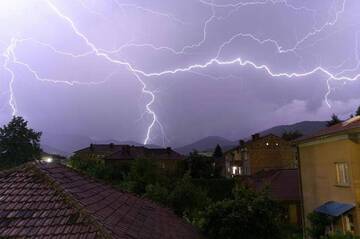
8. My Lightning Tracker
It’s difficult to anticipate the storms that arrive unexpectedly above the heads of hikers. As its name suggests, Mon Traqueur de Foudre records all lightning strikes in the area. The free application also offers a weather radar which allows you to visualize upcoming precipitation.

The +:
+ Almost real-time information
+ Precise location
+ Quite complete free version
Available on: App Store and Google Play Store
9. Nav & Co
Nav & Co is there for those who want to set sail, without losing their footing. The application was born from a collaboration between the French Biodiversity Office (OFB), the Hydrographic and Oceanographic Service of the Navy (Shom) and the State Secretariat for the Sea. Fun and educational, the application encourages sailors to adopt good navigational behavior. Available free of charge, Shom maps allow you to navigate peacefully and anchor in the right place.
The +:
+ “Discovery” mode to discover the secrets of natural heritage
+ A complete application
Available on: App Store and Google Play Store
10. Tide.info
The Marée.info application lives up to its name: easy to use and complete. It is essential for all those who appreciate the French coastline, whether for fishing, swimming or sailing. Available without an internet connection, it provides tide information for the next three days and the current year.

The +:
+ A readable and ergonomic calendar
+ Reliable predictions from official Shom data
+ Quite complete free version
Available on: App Store and Google Play Store

Author Bio
A connoisseur of the digital marketplace and a master of the written word, this 30-year-old English expert brings to the table a wealth of knowledge rooted in the sale of digital products and a passion for blogging that resonates with an audience seeking expertise and insight in the online realm.
Their insights are drawn from hands-on experience navigating the intricacies of e-commerce and content creation—leading the forefront of digital innovation and communication. Whether it’s breaking down complex marketing strategies or sharing tips on how to captivate an online audience, their work stands as a testament to a career built upon successful digital engagement and savvy business acumen.
Stay tuned to absorb compelling content from a voice that not only understands the digital landscape but also shapes its future through every blog post and digital strategy.